

-
This one-pager, "Getting Around on FloodMaps.LSUAgCenter.com " will help you understand the symbols used on the mapping site.
-
The "Point-Specific Flood and Wind Risk" brochure includes general directions for using the site and several screen shots that illustrate the features of the site, including comparing old and new versions of the FIRM at the same point.
The LSU AgCenter Flood Maps website is a DIY educational tool for anyone interested in knowing what the maps say about a specific piece of property. We do offer training and assistance for using the site. Keep in mind that the FIRMs displayed on this site ARE files provided by FEMA for this purpose. However, all official business that relies on the FIRM must be documented with a FEMA FIRMette, which can be obtained at FEMA’s Map Service Center. Also, many entities that rely on the FIRM require a professional Flood Zone Determination.
If you have any trouble navigating the site, email us at floodmaps@agcenter.lsu.edu
| Step | What you do | What you will see |
|---|---|---|
| 1 |
|
You will see a welcome screen and a "Preliminary" alert screen. Close those to see the entire proposed FIRM for your selected parish overlaid on a Bing Road map. The Search Tool will be displayed on the screen. The parishes listed here are those with proposed FIRMS. For access to all parishes, http://maps.lsuagcenter.com/floodmaps. Sign up here to be notified when the map or map status for a parish changes. |
| 2 | Find your property using the Search Tool. You can search for an address or for a "latitude, longitude" coordinate pair. If you do not have an address or coordinates, close the search tool and go to step 3. |
The system will place a pin in the map where it determines the address should be (or where the coordinates are.) It will zoom to that location and produce a Point Information box, with the point identified by its lat/long coordinates. |
| 3 | Turn on the Bing Hybrid (aerial photo and road map) and locate your property. The Hybrid button is on the Layers tool. Also on the layers tool, you can uncheck the box by "Preliminary" or "Future" FIRM to turn that layer off while you look at the aerial photo. |
The system will display an aerial photograph of the area with roads overlaid. |
| 4 | Pan and Zoom to find the exact location you want | |
| 5 | Clear any pins you've dropped on the map while navigating. (Use the Points Tool). |
|
| 6 | Click the map exactly at your point of interest (on your house, on the yard in front of the house, at the corner of your property). |
The system will drop a pin wherever you click the map and display a Point Information box for that point. The Point Info box provides data read from the proposed FIRM (including the flood zone), and from other sources. |
| 7 | Click on the "What Does This Mean" tab at the bottom of the Point Info box |
The What Does This Mean page opens a new tab in your browser. You will get a narrative description of the flood-related information for your point based on the proposed FIRM. The narrative also tells you whether the point is (or is not) in the Special Flood Hazard Area (SFHA, often referred to as "the flood zone") and tells you the insurance and building permit implications of being in that zone, if it was the Effective FIRM. It tells you how to contact the floodplain official for your jurisdiction. You can print that page, or email it to a friend, relative, colleague or client. |
| 8 | Return to the browser tab that has the map with your point identified. Use the Layers tool to return to "Roads" view, uncheck the box for the Proposed FIRM, and check the box for the Effective FIRM. Pull the transparency slider for the Effective FIRM all the way to the right and zoom out a little so you can see the labels printed on the paper map. |
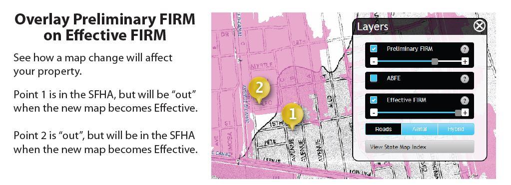
Your pin should be visible in the screen that shows the Effective FIRM. The Effective FIRM is a scan of a paper map. Since it is not digital we cannot read it electronically. The A and V flood zones (which are the ones in the SFHA) are shaded gray and the zone labels and Base Flood Elevation (BFE) information is printed directly on the map. (Remember, these zones on the digital, proposed FIRM are Pink) |
| 9 | See if the property has "moved" in or out of the SFHA. Turn the Proposed FIRM layer back on (check the box in the Layer's tool). | The proposed FIRM will display on top of the Effective FIRM. Wherever you see pink with no gray behind it, the area is being newly mapped into the SFHA. Where you see gray with no pink over it, the area is being re-mapped OUT of the SFHA. The image at the bottom of this page illustrates two points "moving" in these directions. |
| 10 | See if the zone or Base Flood Elevation (BFE) has changed. |
If you need help reading the FIRMs, zones, or BFEs please email the coordinates for your point to floodzonehelp@agcenter.lsu.edu. The coordinates for your point are in the black bar at the top of the point box, and look like this: 29.9984, -89.7232. You should be able to highlight them and paste them into the email message. |
The LSU AgCenter flood map website, outreach program and map-reading assistance are a free service for the people and communities of Louisiana, supported in part by